
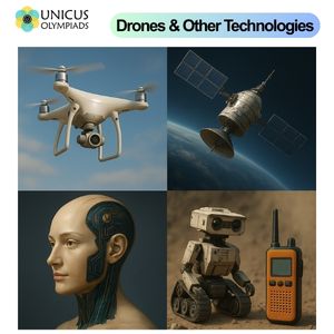
Technology plays a critical role in disaster response by improving efficiency, safety, and effectiveness during emergencies. Among the many technological innovations, drones (Unmanned Aerial Vehicles, or UAVs) have emerged as essential tools in disaster management. Drones are used for a wide range of applications, from providing real-time data and surveillance to delivering supplies in hard-to-reach areas. In this article, we will explore how drones, along with other disaster response technologies, are being utilized to save lives and assist communities during natural and man-made disasters.
Drones are unmanned aircraft that can be remotely controlled or operate autonomously. Equipped with cameras, sensors, and GPS, drones provide invaluable data and capabilities that can assist in disaster management. Their ability to fly over disaster-stricken areas makes them ideal for providing real-time situational awareness, which is crucial in crisis situations.
Drones can assist in search and rescue (SAR) operations by covering large areas quickly and safely, especially in environments that are dangerous or inaccessible to humans.
After a disaster, assessing the damage is crucial for directing resources and organizing recovery efforts. Drones provide accurate, high-resolution aerial imagery that can be used for detailed damage assessments and mapping of affected areas.
Drones are being used to deliver critical supplies to disaster-affected areas, particularly in locations where ground transportation is blocked or difficult to navigate due to debris, flooding, or damaged infrastructure.
In the aftermath of a disaster, communication networks are often disrupted, making it difficult for emergency responders and victims to coordinate effectively. Drones can help restore communication capabilities in these areas.
Satellites play a crucial role in disaster response by providing high-resolution images of affected regions. Satellite technology is used to monitor environmental conditions, assess damage, track storm systems, and coordinate aid efforts. Some key uses include:
Combining drones with artificial intelligence (AI) allows for more advanced disaster response capabilities. AI-powered drones can analyze imagery in real time, identify patterns, and automatically detect hazards like fires or floodwaters, allowing responders to focus their efforts on the most critical areas.
In addition to drones, robots are increasingly being used in disaster response, particularly in search and rescue operations. Robots can navigate dangerous or unstable environments, such as collapsed buildings or hazardous chemical sites, to locate survivors or assess damage.
During disasters, communication is key to coordinating rescue efforts and providing timely information to the public. Various technologies are used to restore communication systems in disaster-stricken areas: