Join Our WhatsApp Channel for Exam Updates | Click here to Register for Olympiad Exams | Check Exam Dates here| See Marking Scheme here | Frequently Asked Questions (FAQs)
Unicus Olympiad Exams

How Do Lines Like the Equator or Prime Meridian Help Locate and Divide Earth?

Geographical lines like the Equator and Prime Meridian play an essential role in how we locate positions on Earth and divide the world into different hemispheres. These lines form the basis of the global coordinate system, which allows us to determine the exact position of any place on the planet using latitude and longitude. In this article, we will explore how these lines divide Earth and the different types of latitudes that help us pinpoint specific locations, along with examples of their significance.

The Equator and Its Importance

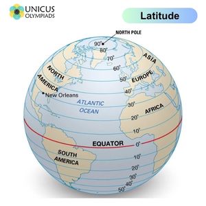
The Equator is an imaginary line that divides Earth into two equal halves: the Northern Hemisphere and the Southern Hemisphere. It is located at 0 degrees latitude and is the longest line of latitude on Earth, measuring approximately 40,075 kilometers (24,901 miles). The Equator plays a significant role in climate, geography, and navigation.

Key Points About the Equator

  • Geographical Division: The Equator divides the Earth into two hemispheres, the Northern Hemisphere and the Southern Hemisphere, with equal distance from the North Pole and the South Pole.
  • Climate: Regions around the Equator tend to have warm temperatures year-round and are characterized by tropical climates. This is because the Equator receives direct sunlight throughout the year.
  • Navigation: The Equator is a reference point for determining latitude, helping navigators and geographers calculate the position of places on Earth.
  • Examples: Countries that lie on the Equator include Ecuador, Brazil, Kenya, Indonesia, and Colombia.

The Prime Meridian and Its Role

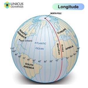
The Prime Meridian is another key geographical line, located at 0 degrees longitude. It divides Earth into the Eastern Hemisphere and the Western Hemisphere. This line runs from the North Pole to the South Pole and passes through Greenwich, England, giving it the name Greenwich Meridian. The Prime Meridian is vital for determining time zones and for global navigation.

Key Points About the Prime Meridian

  • Geographical Division: The Prime Meridian divides Earth into the Eastern Hemisphere and the Western Hemisphere, with the Eastern Hemisphere lying to the east of the Prime Meridian and the Western Hemisphere to the west.
  • Time Zones: The Prime Meridian is the basis for the world’s time zones. The time at the Prime Meridian is called Greenwich Mean Time (GMT), and the world’s time zones are defined relative to this line.
  • Examples: Countries that the Prime Meridian passes through include United Kingdom, France, Spain, Algeria, and Greenland.

Types of Latitudes

Latitude lines are imaginary lines that run parallel to the Equator. These lines measure the distance north or south of the Equator in degrees. Latitude is crucial for determining the climate and location of a place on Earth. In addition to the Equator, several other important latitude lines divide the Earth.

Types of Latitudes and Their Importance

  • Equator (0° Latitude): As previously mentioned, the Equator is located at 0° latitude and divides the Earth into the Northern and Southern Hemispheres.
  • Tropic of Cancer (23.5°N): This line is located at 23.5° North of the Equator. It marks the northernmost point at which the sun can be directly overhead at noon. The Tropic of Cancer passes through countries like Mexico, Egypt, and India.
  • Tropic of Capricorn (23.5°S): The Tropic of Capricorn is located at 23.5° South of the Equator. It marks the southernmost point at which the sun can be directly overhead at noon. This line passes through countries like Australia, Chile, and Brazil.
  • Arctic Circle (66.5°N): Located at 66.5° North of the Equator, the Arctic Circle marks the region where, during the summer solstice, the sun does not set for 24 hours, and during the winter solstice, the sun does not rise for 24 hours. This line passes through countries like Norway, Sweden, and Russia.
  • Antarctic Circle (66.5°S): Located at 66.5° South of the Equator, the Antarctic Circle marks the region where, during the summer solstice, the sun does not set for 24 hours, and during the winter solstice, the sun does not rise for 24 hours. It passes through Antarctica.
  • North Pole (90°N): The North Pole is located at 90° North latitude, marking the northernmost point on Earth. It is surrounded by the Arctic Ocean and is the point where all lines of longitude meet.
  • South Pole (90°S): The South Pole is located at 90° South latitude, marking the southernmost point on Earth. It is located on the continent of Antarctica and is a key point for research stations and environmental studies.

Importance of Latitude and Longitude

Latitude and longitude are the two main coordinates used in the global coordinate system to pinpoint locations on Earth. Latitude gives the north-south position, while longitude gives the east-west position. Together, they form a grid that allows for precise location identification anywhere on Earth.

Examples of Latitude and Longitude Use

  • GPS Navigation: Latitude and longitude are essential for GPS systems that help navigate cars, smartphones, airplanes, and ships. For instance, New York City is located at approximately 40.7128° N latitude and 74.0060° W longitude.
  • Weather Forecasting: Meteorologists use latitude to determine the climate of a region. For example, areas near the Equator experience tropical climates, while areas near the poles have polar climates.
  • Time Zones: Time zones are based on the Earth’s division into longitudinal lines, where each time zone is about 15 degrees apart, with the Prime Meridian as the reference point.

Fun Facts About the Equator and Prime Meridian

  • Equator’s Length: The Equator is approximately 40,075 kilometers (24,901 miles) long, making it the longest line of latitude.
  • Unique Locations: You can stand at the intersection of the Equator and Prime Meridian in Ghana, at the Royal Observatory in Greenwich, England, which is considered the birthplace of timekeeping.
  • Crossing the Equator: In many cultures, crossing the Equator is celebrated with rituals or ceremonies. For example, sailors who cross the Equator for the first time are often given a "Crossing the Line" ceremony.
  • Longitude and the International Date Line: The Prime Meridian divides the Earth into Eastern and Western Hemispheres, and the International Date Line (IDL), which runs roughly along the 180° longitude, determines the change of calendar days.
70%